|
ABOUT KITSAULT »
THE OWNER
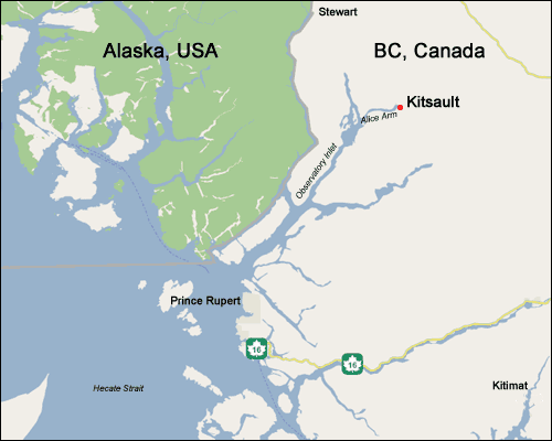
LOCATION
IMAGE GALLERY
HISTORY
MEMOIRES
FIRST NATIONS
British Columbia’s wilderness is a real work of nature.
It is made up of mountain ranges that divide the province
into a number of valleys and a large central plateau. Mountain
ranges that make up the majority of the northern landscape
are the result of volcanic fires that folded and were then
raised below the earth’s surface. Heavily forested
valleys were carved out by glaciers that at one time covered
most of the province.
B.C’s natural precious environment consists of forests,
grasslands, meadows, wetlands, rivers and inter-tidal and
sub-tidal zones. As a result, BC houses the greatest range
of plants and mammals of any Canadian province.
A lot of northern BC is preserved and protected by various
provincial parks and nature reserves. For the adventurous
nature-loving traveller, Northern BC offers turquoise-coloured
glacier lakes, alpine meadows, hot springs, volcanic cinder
cones and even a miniature Grand Canyon!
Ten Interesting, Unique Features of Northern BC
 Prince Rupert’s harbor is the third-deepest
natural harbor in the world, behind just Buenos Aires, Argentina
and Sydney, Australia. Prince Rupert’s harbor is the third-deepest
natural harbor in the world, behind just Buenos Aires, Argentina
and Sydney, Australia.
Canada’s smallest official railway is the
2km Fort George Railway in Prince George.
BC’s highest point is Fairweather Mountain
at 4,633 meters (15,196 feet) on the BC/Alaska border in
the Coast Mountains.
Prince Rupert has the highest average annual precipitation
of any city in Canada – 2,552 mm (8.5 feet).
In Northern BC, excluding Prince George, there
is an average of 1.8 people per square kilometer, making it one of
the least densely populated areas in the world south of
the 60th parallel.
The world’s longest unlogged coastal temperate
rainforest is the 4,050 square kilometre (1,620 square mile)
Kitlope Valley, now a heritage conservancy.
Langara Island, on the northern Haida Gwaii (Queen
Charlotte Islands), holds BC’s record for rainy weather
– 300 wet days in 1939.
BC’s coldest day was in Smith River, just
south of the BC/Yukon border. On Jan. 31, 1947, the mercury
plunged to a frigid –58.9°C (-74°F).
BC’s windiest place is Cape St. James, at
the southern tip of Haida Gwaii. The wind blows there 99
per cent of the time. On average, a gale gusts through Cape
St. James every three days.
The longest continuously occupied non-native settlement
in BC is McLeod Lake, established in 1805.
Top of Page
|